Friday 25 January 2013

Le Grande Nat Park to Ceduna


What a week of contrast, from the most beautiful beaches (ridiculously beautiful as one backpacker told us) to the Super Pit then leaving Western Australia, a very beautiful state and into South Australia across the Nullabor .
We spent the weekend in Le Grande National Park camping at Lucky Bay.  We set up camp and went for a long walk along the beach, the whitest sand we have ever seen and the clearest water, and the colour, unbelievably turquoise. There was an area where there was weed washing up that made the beach look messy, but on the whole it was beautiful. Garry climbed a hill after lunch for some magnificent views of the bay, islands and ocean that take your breath away. The next day we decided to go driving to explore the rest of the park, first was Rossiter Bay which was long and nice, then onto Hellfire Bay. Well the first glimpse here had us seeing the most beautiful beach we have ever seen, in Australia or anywhere. The beach was so white with not an impurity on it, no weed, no shells, no rubbish and the water, so clear, so many shades of blue, you can’t describe it, just perfect.  After walking the length of the bay and just spending time here marvelling at the beauty, we dragged ourselves away and on to Le Grande beach and again just beautiful. This beach was also white, long (all the way back to Esperance 60kms away), and the water pristine again. We swam here even though the water was quite cool. We just had to go in.  Garry then snorklled and even though there were no fish or coral, the visibility was the best he has ever seen and he paddled around for ages looking at the water and the pure white sandy bottom being washed in the waves.
Our first walk on Lucky Bay beach

Lucky Bay from the granite hilltop - campground mid left

granite islands keeping the waves down

Lucky Bay

Hellfire Bay

It is so hard to photograph sand so white and water so clear

sooo clear

Our favorite beach so far


Enjoying the waves on Le Grand Beach

heading for the snorkel and back in again...

Catching rays not waves

Thistle Cove


Just one last look at Hellfire Bay

We found it hard to drag ourselves away from the beautiful beaches and water on Monday morning, but after one more look at Hellfire Bay and another bunch of photos, we headed for Kalgoorlie travelling via Coolgardie.
Coolgardie buildings reflecting bygone good times  

Garry had rung ahead and booked on a tour of the gold mine which he took next morning.  Gold has been mined since 1895 and the area called the Golden (square) Mile had more than 80 steel framed poppet(lift) heads with hundreds of other hand dug shafts and thousands of kilometres of tunnels dug down to 1,700m deep and with over 2,500km of narrow light rail line installed.  Alan Bond came up with the idea of buying all the leases up and digging one large open cut mine to recover all of the gold in between all of the smaller mines.  The Super Pit now owned 50% Barrack / 50% Newmont, has been developed to be 4km long, 1.5km wide and 720m deep and growing.  The mine operates 44 Cat793 trucks moving 300,000t of material per day resulting in 40,000t of high grade ore for processing, With the remainder being placed in the Marginal, Low Grade, or Waste dumps.  The tour was excellent offering a good look inside the pit, around the processing plant and from good pit edge lookouts.  They have recently discovered a large underground workshop area still intact with jarrah benches, tools, and office furniture complete with plans and mine drawings and are in the process of recovering it all by large crane lowering people over the side wall and into the reopened tunnel.
Kalgoorlie buildings are not plain

even the dome on the clock tower is 24ct gold foil plated as of 2012

Beaut old pub

Super Pit 720m deep, the bench near top of opposite wall is being widened 350m 

drilling and excavating the wider bench

240t truck passing tunnel from old underground mine

heavy duty shovel bucket .

Wednesday and we set out for the Nullabor crossing and onto South Australia. Garry decided to play the Nullabor links which is the world’s longest golf course. There are 18 holes spread over 1,365km from Kalgoolie to Ceduna. Having to stop at towns and roadhouses along the way broke the trip up and made us take regular breaks. Carol made a photographic record of the golf whilst Garry enjoyed the challenge of the course. 
Hole 1 of the Nullabor Links, looks great at this stage...

the fairway grass changes a bit as you go!!!  Note the guide posts marking the fairway and the Japanese flag showing where the flag is.

We were lucky that the first day of travelling was overcast with the wind behind us, and the second was overcast with very light rain so made the trip very cool as apparently it can be very hot travelling the Nullabor. We also free camped the second night near the 
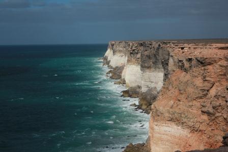
cliffs of the Great Aust. Bight.  A weather front moved through late in the day which meant we experienced a delightful evening / night of sea breezes averaging 100+kph with gusts well in excess.  We thought the van was going to blow away on several occasions.  The sun peeped out right on sunset giving us some good photos of the cliffs but the wind still howled through it. The road itself it wide, straight and in excellent condition. It is a lot more vegetated then we thought it would be, with plenty of wildlife of course, emus, kangaroos, eagles, dingos and a camel. There were even emus walking around on a couple of the golf holes.
Our first look at the cliffs of the Bight

The sun peeking through but you can't photograph the 70knot winds!!!

Sunny days and great views

At the Head of the Bight where 90 southern right whales come each year during winter

We saw camels, roos, dingos, eagles, emus but no wombats

 The third day on the Nullabor had a bit more to see with several stops to view the ocean cliffs and a change in the scenery from flat scrubby plains to rolling wheat fields nearer Ceduna, although the whole way looked dry.  Ceduna looks nice and peaceful and we are ready for bed after a walk along the pier in the cold wind.  Turns out we timed our trip right with Ceduna having 47 deg heat yesterday and 25 deg maximum and cold wind today.   
Ceduna beach - van park right behind the trees mid photo

Friday 18 January 2013

Pemberton to Esperance


We are travelling again and feel like we are not doing much until we look back at this time and realise how much we have seen and experienced.  It’s a great life!!
Having been down the coast road last week with Brendan and previously when visiting Kirsty & Ben in Bunbury, we headed across the SW corner into the big timber country and had our first stop outside Pemberton.  We stayed in a free camp in a National Park near Big Brook Dam in amongst huge Karri and Sequoia trees; the silence at night was deafening after 3 weeks in town.  Timber was and still is the main industry in town and we took a ride on an old Tram from town out into the forest past the hardwood saw mill, the Cascades waterfall (not very impressive in this dry season), and over several timber bridges built in the 1800’s.  We also past near an area of old growth forest which is natural and unlogged (no more than one tree cut down per hectare when inspected).  The trees are mostly Karri & Marri which are both eucalypts and are huge, growing to 65m high in 85 years.  Pemberton is a very pretty little town with beautiful green grasses and flowers in bloom in most gardens.  Carol made the climb up the Gloucester tree which is a 75 m high Karri tree with a 3 level fire lookout built at the top.  It was an impressive climb but the views were only tree tops, I was told on the return.
Pemberton Forest Tram

The Cascades

Pemberton Pool in the tall timbers

Gloucester Tree fire lookout

"I did it !!"

Walpole

Coal Mine Beach

We moved on through the forest and out onto the coast at Walpole. This is a very neat little seaside town spread around a large inlet.  One of the beaches was called Coal Mine Beach and we called in for a look but couldn’t see any filthy black stuff.  A little east of Walpole is the attraction called ‘Valley of the Giants’ which is a tree top walk among the huge jarrah and tindle trees.  This is very interesting and the walks include some huge trees in height and diameter.  Next along the coast is Denmark where we had our next stop at the Rivermouth Van Park.  As it suggests, the park is on the shores of the river mouth and the inlet.  It is a very pretty park and the town is very neat.  All of the southwest is beautiful and green with obviously much more rain than anywhere else in the state we have seen so far.  The huge Karri forest runs right to the coast and the rivers have grassy banks to the water’s edge.  All of the towns along this coast have several beautiful grassy parks.
Tree top walk in Valley of the Giants

Inside a large Tindle Tree still alive but hollow in the base

Denmark river mouth and inlet - van park on right

Up river

Our next stop was Albany which is a large town (>30,000 residents) and is surrounded by stunning coastal scenery.  It is again based around an inlet, in this case King George Sound, and much of the coast here has huge outcrops of granite rising out of the sea as islands and forming the coastline and hills.  The sound contains a small bay called the Princess Royal Harbour which was the first port in WA before Fremantle was established and took over as the states’ major port.  The harbour still exports wheat, wood chip, and other products.  Albany was one of the first colonies settled in WA and has plenty of history to entertain us visitors.  There is a large military fort on a hill overlooking the entrance to King George Sound which includes large guns placed to defend the area from sea attack.  There would have been a very impressive sight in November 1914 when 36 troop ships from Australia and New Zealand assembled to sail troops to Egypt to join the war in the desert.  32 ships carrying 30,000 men and their horses sailed in one group with many seeing Albany as their last view of Australia.  The beaches are beautiful with fine white sands, calm clear waters and good beachside parks.  On the western side of the sound, the ocean side of the peninsular has a spectacular granite coastline with The Gap and Natural Bridge being ideal photo locations.  The old whaling station operating until 1976 has been turned into a very good tourist facility with good displays and movies.  A replica of the Brig ‘Amity’ has been built and is located in the entry to town and gives us a great sense of how small the ships were in 1829 when the ‘Amity’ sailed from Sydney to Albany to establish the colony carrying 65 people, pigs, cows, and 6 tons of salted beef and pork, tools and plants and seeds.  We stayed at the Rose Gardens Van Park out on Emu Point which is on the waterfront and was old but very pleasant with beach walks being very enjoyable.  We loved the gardens in the area most of which contained beautiful rose gardens still in full bloom.  The main street of Albany is an interesting stroll with plenty of interesting shops to entertain those shopaholics amongst us.  We were strong and saved our cash but spent plenty of time being tempted.  The Anglican Church in the main street is a very interesting building over 160 years old with excellent stained glass windows.  Having spent this week’s allowance on repairs to our air conditioner, we headed for another free camp on the banks of the Pallinup River 120kms east of Albany.  It was a basic bush camp, but again, very quiet.  
Our Albany van park was at the end of the white beach on Emu Point

Canon protecting King George Sound entry

Undedrground shell storage

Submarine torpedoes and warship gun turret

The command post and lookout over the entry

Princess Royal Harbour still an active port with grain & wood chip

The Old Farm on Strawberry Hill in Albany, the oldest continually operating farm in WA

House built in 1837, furnishings all beautiful and old

Albany Coastline


Natural Bridge

The Gap

Garry in front of a Pigmy Blue Whale skeleton

The last whaling boat used at Albany retired in 1976 built in Norway in 1948

Jimmy Newells cove


Wildflowers still in bloom on the coast

An early start saw us into Esperance for lunch and off on the Great Ocean Drive.  This is 40 kms drive along the coast and back past the huge saltwater Pink Lake; (another one which also wasn’t pink).  The coast is made up of beautiful beaches and granite rocky cliffs and islands.  The water has the most beautiful colours from white, light green and the deepest brightest blues while the sand is white, fine and very soft.  The ocean off shore is the Southern Ocean and you can tell there are ice blocks floating in it not far away but the locals and holiday makers didn’t mind with plenty of them swimming, board riding and wind-surfing.  Our park is again on the beach front and the evening beach walks are very relaxing.  
Full size replica of the Brig 'Amity' sent to establish Albany

The Crew's Quarters

The Officer's Quarters
Our first view of the Esperance beaches


This beach was rated the 'Best Beach in Australia'


The Pink Lake - an inland salt water lake

Esperance waterfront walk

We are of the conclusion that the coastal areas anywhere south of Perth are some of the best we have visited anywhere.  Everyone that told us to come here was right; it is a beautiful area and we could easily spend more time here, if only it wasn’t so far from family.